by Lukas Stevens
Lukas Stevens is a Planning and Data Analyst at Copenhagenize Design Company's Montreal office, where he works on cycling network plans for many of our North American clients. He is originally from Hamburg, Germany and has a Masters in Urban Planning from McGill University.
At Copenhagenize Design Co., we are both optimists and realists. We know that the bicycle revolution in our urban centres is well on its way and that best-practice bicycle infrastructure as seen in Copenhagen is the optimal solution to accommodate the hordes of people of all ages and abilities who are capable and ready to take to the world’s streets on their bikes.
Many of the arguments brought forward by skeptics disputing that Copenhagen-style bicycle infrastructure would work in their cities have proven to be untrue. Too expensive? In Denmark and other places we have seen that a high bicycle modal share actually saves society money in the long run! There’s not enough space on roads for such wide bike lanes? Not if you start looking at the amount of people a street can move rather than just the number of cars. Stores suffer when removing car parking? Actually we see bike lanes improving business. Our city will never have over 50% of citizens on bikes like in Copenhagen? Maybe not, but 40 years ago neither did Copenhagen, and why couldn’t your city get to 15% instead?While we are happy to see more and more cities slowly jump onboard the bicycle urbanism train, we still need to ensure immediate safety for bicycle users in our cities today, especially in contexts where protected infrastructure may not be politically feasible quite yet. Here, we want to help tackle the question:
Intersections, for all road users, are the most critical points in a street network as a bicycle user moves through the city. Here in Montreal, for example, a 2005 study showed that 58% of all collisions involving bicycle users happened at intersections. More recent data shows a similar picture. Let’s be clear, this doesn’t mean that cycling is inherently dangerous, but while cars and pedestrians have their own traffic lights, signs and paint that guide them through the intersection, in most cities bicycle users are often left to their own devices. In Copenhagen we see that small, low cost adjustments to intersections that can be easily implemented in essentially every context and vastly improve the safety for bicycle users. Pulled-back stop lines for cars, coloured paint through the intersection, protected corners at streets with heavy right-turn car traffic, and designated traffic lights – Copenhagen shows us that these small changes, which are cost effective and in most cases not particularly controversial have a huge positive effect for bicycle users’ safety. The city of Montreal, home of our North American Copenhagenize office, is the perfect context to demonstrate how easily intersections can be retrofitted with Copenhagen-inspired bicycle infrastructure design. Recently, the local borough of Rosemont-La-Petite-Patrie has added a number of temporary plastic posts for improved intersection protection from motor vehicles. These measures are cheap and the City is able to install several of them within a week. Montreal has a diverse collection of facility and infrastructure types built over decades of ever-changing design standards. There is no place this is more noticeable than at intersections where these different types of infrastructure sometimes clash. Sharrows meet bi-directional cycle tracks, bi-directionals on a one-way street meet bi-directionals on a two-way street, one-way streets with a contraflow lane meet other one-way streets without a contraflow lane, and so on. Often the transitions follow little conventional traffic logic:
What small short-term improvements can be made in cities to improve bicycle users’ safety until there is political will to redesign our streets for people?
 |
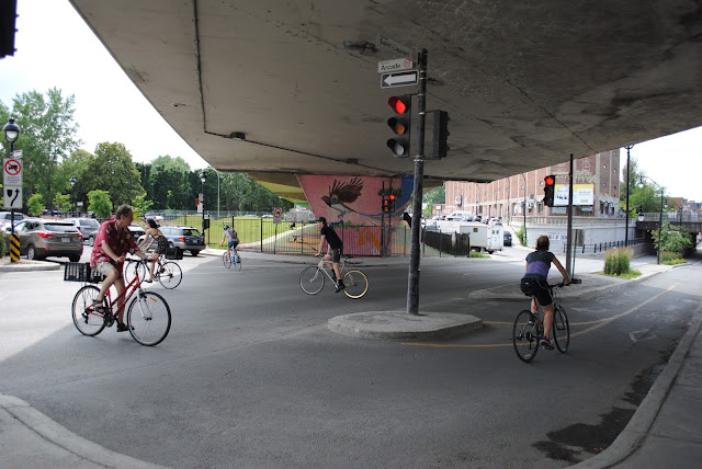
| Despite new Copenhagen-style handlebar bling, this Montreal intersection suffers from severe two-way to one-way cycle track confusion |


Montreal’s mish-mash of infrastructure types and no clear standard for design is a perfect place to show how quick fixes to different intersections are transferable to almost any urban context in the world – a demonstration of the simple elegance of the Copenhagen intersection design model.
---
While other parts of Montreal have a more-or-less cohesive network of bicycle facilities, the absence of infrastructure in the south-west of Montreal’s downtown is striking. There are very few safe cycling routes through this neighbourhood and a number of large highway barriers for pedestrians and bicycle users. Atwater Avenue is one of the most important north-south streets in the area and one of the few streets that connects under a major highway. Atwater was also the subject of a recent controversy when the City decided that pedestrians and bicycles could share the sidewalk through said underpass while cars speed through three vehicular lanes in each direction. The media, opposition politicians and local advocacy groups sharply criticized this arrogance of space, especially since this part of Atwater is on a steep slope and the potential for collisions increases dramatically at higher speeds. |
| The City's recent attempt to ask bicycle users and pedestrians share a narrow sidewalk |
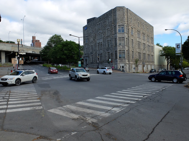
Atwater Avenue should undoubtedly have protected bike lanes but even that does not address the additional danger that bicycle users currently face just beyond the underpass at the bottom of the slope - the Atwater & Saint Antoine intersection. Once bicycle users reach the bottom of the hill and the end of the underpass, they face an intersection with a large number of right-turning cars heading to a highway on-ramp, as can be seen in the picture below. The potential for collision here is high – as bicycle users share the road while only one single traffic light manages this junction with heavy, and potentially deadly machines moving downhill at high speeds.
 |
| Cars turning right (see white vehicle) pose a real danger to bicycles heading downhill |
It is not only the traffic light that is problematic here. Streets are typically designed to offer the fastest turning radius to automobiles. In other words, if there are no physical barriers that force cars to slow down, they generally won’t. Since bicycles are often in motorists’ blind spots while turning, there must be visual cues that remind everyone – especially motorists – of the vulnerable road user’s presence.
Over years of developing and revisiting best practice intersection design, the City of Copenhagen has implemented guidelines that could address the unsafe features observed at the Atwater & Saint Antoine intersection through inexpensive features like paint, lights and a protected corner. Here is an example of what these interventions might look like:

1. The first major change is the addition of bicycle infrastructure on Atwater to designate space for bicycle users, which in the case of this intersection will be a necessary adjustment to making it safer for vulnerable road users. Physical protection of bicycle users and pedestrians, each with their own space, throughout the underpass leading up to the intersection is key for safety on busy streets.
2. The second change is to pull back the stop lines for cars. In most cities cars and bicycles share a stop line at the intersection even when bicycle infrastructure is present, which means that bicycles are waiting in a car’s blind spot where they might not be seen. By placing bicycles further in front, motorists are reminded of their presence and it allows bicycle users to get a head start when the light is green.
3. Bicycle users also require a few seconds to stabilize their movement as they start cycling forward. Giving bicycles their own traffic light and a 4-5 second head start over cars ensures that bicycle users can gain momentum safely and are offered priority in their straight movements over right turning cars.
4. The green paint in the intersection, which follows the natural path cyclists take, functions similarly to the pulled back stop line in that it creates better awareness and visibility for the potential presence of cyclists. However, it also designates space to the bicycle as a valuable and legitimate mode of transport that is different from pedestrians and motorists.
5. One of the major concerns for this intersection is the potential for right turn collisions between cars and bicycles. In order to avoid this, physical protection and appropriate signage is necessary to separate bicycles and cars from each other. An effective solution in Copenhagen can inspire Montreal with designated traffic lights for all modes and refuge islands to provide vulnerable road users a space to wait for their light. Both cars and bicycle users here have two signals: One is pulled back and allows for each user to take turns crossing each other with a protected light phase. The second signal is the ‘normal’ signal further ahead that shows bicycle users and motorists when it is their time to move through the intersection. |
| A protected right-turn corner in Copenhagen with two sets of signals for bicycle user safety |
---
In 2016, our Copenhagenize office performed a Desire Lines Analysis here in Montreal, studying how bicycle users interact with the built environment through certain intersections. The crossing of Saint Urbain Street and de Maisonneuve Boulevard was chosen as one important intersection to study, in light of it being one of the most dangerous intersections for bicycle users in the city, witnessing the highest number of collisions in 2013 and 2014. In a best-case scenario, the City of Montreal would convert two-way cycle tracks like the one here on de Maisonneuve into unidirectional paths, helping to rectify many of the conflicts we observed in our study but, again, for the sake of this exercise let’s look at constructive design solutions in the immediate.A major source of conflict today between cars and bicycles is a result of westbound cars along de Maisonneuve Boulevard making left-hand turns onto Saint Urbain street, as shown with the red arrows in the map of the improved intersection. Bicycles are left in the turning path of cars and, in the case of bicycles heading with the flow of traffic, in the blindspot:

1. Use bicycle-specific traffic lights to separate the movements of cars and bicycles. A bike signal gives bicycle users a few second head start, and then cars are given their own brief period at the end of the light phase for left-hand turns while bicycles are told to wait. Montreal has already added these signals to a number of other intersections that sees heavy left-turning traffic.
2. Further visual cues such as pulled back stop lines and green paint through the intersection remind everyone of each other’s presence also showing where conflict between cars and vulnerable road users might occur. It is interesting to see that bicycle users generally ignore their stop line at the intersection to push themselves up ahead of idling cars naturally:
 |
| Bicycles riders often push themselves ahead of idling cars in order to be seen and safe |
3. The introduction of a bus island gives pedestrians a safe space to enter and exit the bus while bicycles pass between the bus island and the sidewalk. This way bicycle users aren’t in danger of being hooked by the bus pulling over to the bus stop and pedestrians and bicycle users are physically separated. The bus island can also function as a protected corner for right-hand turns. Montreal actually has implemented a bus island further north on Saint Urbain Street already in a few locations (as can be seen below).
 |
| One of several protected bus islands in Montreal – more should be implemented across the city to protect bicycle users. |
4. Again, paint (in this case crosswalks across the cycle track) highlights potential conflict zones and reminds pedestrians and bicycle users of each other’s presence and legitimizes pedestrians crossing the intersection. In the Danish context, bicycles have the right of way and pedestrians can cross when it is safe to do so.
--- All of these small-scale changes can have huge impact to safety at the most probabilistically collision-prone parts of the city for vulnerable road users.


