Mikael, on behalf of Copenhagenize Design Co., is a teacher in the Bicycle Urbanism Studio led by urban liveability expert Bianca Hermansen at the Danish Institute for Study Abroad (DIS). Since 1959, DIS has given American students the chance to study in Denmark. Our Bicycle Urbanism Studio features American architecture students.
Mikael led a portion of the course involving a massive Desire Lines analysis of two intersections at either end of the Dybbøls Bridge in the Vesterbro neighbourhood. The students' final project was broader than that. They were given the task of rethinking the entire area. The wide swathe of unused railyards, access to the harbour and bicycle traffic through the area.
Working with the students was brilliant and inspiring. Mikael was also an external examiner on the final projects at DIS. We thought it worthwhile to get the students to present their projects in short form. Showing off their abilities, ideas and visions. We'll divide them up into two articles. Here's the second one.

Our Urban Design Studio features the analysis of the existing bicycle infrastructure connecting Vesterbro, Fisketorvet Mall and the Fisketorvet Bridge and a proposal based on the information documented in our research. The research component of the studio consisted of video taping bicycle behavior (monumentalists, recklists, and conformists), counting the number of parked bicycles by the hour, and documenting conflict zones. These details, which are so often overlooked by the every day user, are the components that we, as designers, used to design. This form of development is called "fact-based decision making" and is a form of research that I found to be enlightening. At a personal level, I chose to focus on how to best resolve areas of conflict between cyclists and pedestrians, reduce automobile traffic, and facilitate the needs of families living in Vesterbro.
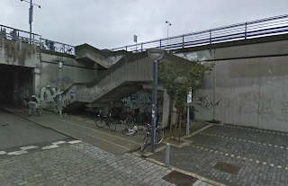
A whopping twenty-four percent of residents in Vesterbro own cargo bikes. This means that these people have found an environmentally friendly way to not only travel, but perform errands, whether that be grocery shopping, dropping off kids at friends' houses, or picking up flowers. Improving safety conditions for these travelers is the driving factor behind my design. Also, a statistically significant aspect of the project is how many users per day currently use the inconvenient staircase depicted below. A staggering 4,700 users on the day of our observation. And, with the installation of the snake, we can expect travelers between Vesterbro and the bridge to increase.
 Nearly 5,000 travelers use this staircase to get to their final destination, daily. Proposing a convenient and safe alternative to this is one of the demands of the project.
The plan proposed is meant to be a realistic reconfiguration of the site. The bridge, which currently has a large void ought be filled. With the creation of new space I propose a walking promenade with a series of overlook and nodal spaces which allows for people to sit and watch pedestrians go along to either the mall or Vesterbro. Beneath the bridge, and expanding northeast and southwest is a park which connects with the larger context of Amagerfaelled. Access would be gained from the s-tog platform or ramps descending from the bridge.
Riders ascending to the level of the shopping mall are greeted by a bi-directional bike path, with distinguishable paving patterns, to clearly delineate spatial usage. By combining the bike lanes, pedestrians are no longer at risk of accidents by bikers. I have proposed to close down one of the ramps curving up to the plaza level and be replaced by a department store and a series of mom and pa shops which align the northeastern edge of the street.
 A section of spatial types along the proposed bridge shows which type of users are being provided for; green= pedestrian, yellow= bicycle, red= automobile, blue= bio-swale, and orange= nodal space. This section cut goes through two nodal spaces, the larger of which overlooks green space to the northeast.
ELAINE STOKES

The area surrounding the Fisketorvet shopping center consists of zones of extremely high and extremely low use. While the bridge crossing over the Dybbølsbro S-Tog station experiences such high pedestrian usage during afternoon and evening hours that people overflow sidewalks and crowd the cycling lane, the unused land below the bridge is left completely vacant for the majority of the day. Additionally, most road space leading up to Fisketorvet is allocated to cars, even though car traffic falls far behind cyclist and pedestrian traffic during all hours of the day.
The Cykelslangen, or “Bicycle Snake,” is the current solution supported by Copenhagen municipality to improve cyclist flow through the Fisketorvet-Dybbølsbro area, yet this design fails to improve the livability of the neighborhood, nor does it increase resources for pedestrians who pass through the area.
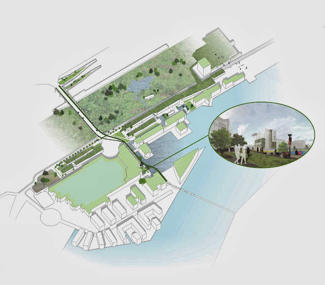
Instead, the Inhabit—Habitat proposal seeks to remedy the Fisketorvet-Dybbølsbro area by creating accessible connections between retail, the harborfront, and open green space, while also improving storm water management and the natural habitats of the site. Instead of simply remedying the cyclist route through the area, this proposal calls for a complete restructuring of the traffic hierarchy of the site.
First, by transforming the Dybbølsbro Bridge into a gradual ramp rising from the ground level of the Fisketorvet mall to cross over the S-Tog stop, cyclists could remain at ground level while traveling past the mall from Brygge Broen. This, in turn, would eliminate the need for the Cycle Snake to be elevated.
Next, the car entrance to Fisketorvet would be relocated to the southwest side of the mall and the freeway along Kalvebod Brygge would be simplified and narrowed, making the northern side of Fisketorvet available for additional retail space reflecting a typical Copenhagen streetscape.

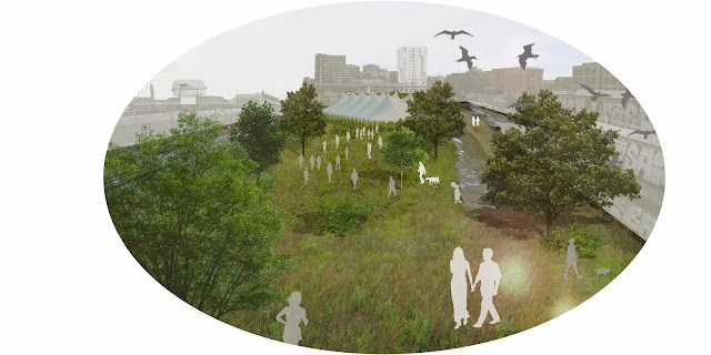
Finally, the unused land adjacent to the S-Tog stop would be allowed to return to a natural habitat, with inlets from the harbor uniting the park to the new retail development and the waterfront. Through these measures, the disjointed spaces of the Fisketorvet-Dybbølsbro zone would be refitted to form a cohesive, environmentally conscious, accessible, and livable neighborhood center.
MICHELLE WOODS

Urban Current: a surge of life through Dybbølsbro
With 26 total hours of recorded video footage made up of 13 hours of documentation at the Fisketorvet Shopping Center intersection and 13 hours at the Dybbølsbro intersection, a large amount of data and insight into how cyclists move through and within our site was observed.
First Impressions
From on-site observations and viewing of the video footage, the first thing I thought of was how this site did not seem to reflect the values of Copenhagen. Cars and other vehicular traffic are placed ahead of cyclists and pedestrians. The infrastructure allows for easy and flowing car movement, while cyclists and pedestrians face crowded spaces, stairs, and other obstacles throughout the site.
The site also creates a large disconnect between the vibrant neighborhood of Vesterbro and the harborfront. While walking across the Dybbølsbro bridge, there seems to be no presence or atmosphere. The punctuation of the bridge in the Fisketorvet mall also does not add much to the site.
Proposed Solution
A 20 year plan that restructures the site will help to bring life back to the area.
The first proposed action would be to make a huge infrastructural change. A bridge with infrastructure of separated lanes for cyclists and pedestrians should be built on both sides of the car lanes. Eliminating the bridge and flattening the infrastructure by Fisketorvet would result in a ramped structure that would curve to connect cyclists and pedestrians directly into the ground level next to the mall, creating a smooth connection. A new, normal intersection would be created. This change places the needs of cyclists and pedestrians ahead of that of cars and stays in line with the values of Copenhagen.
The next step in this plan would be to develop the empty land beneath the current bridge. Having a development of mixed-use buildings and great public streets and gathering spaces can bring a new vibrancy to the site. This development would also be able to pay for the large infrastructural changes that would occur prior to this.
Although a large and ambitious plan, I think that this restructuring and development of the entire site would in the long run bring a new and exciting life to the site that would celebrate the everyday cyclists and pedestrians.


